
Check the points below to see the famous cities in Argentina information in details are:-
The three best destinations reflect Argentina’s uniqueness combination of natural beauty, cultural richness and historical significance.

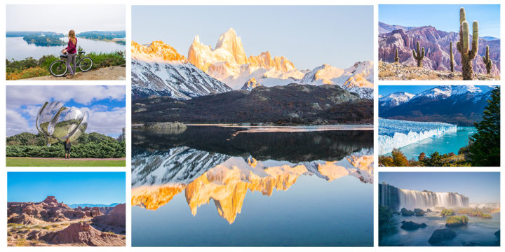
- Iguazú Falls (Cataratas del Iguazú)
Location:– Northeastern Argentina on the border with Brazil
Popularity:- One of the largest and most impressive waterfall systems in the world, Iguazú Falls is a UNESCO World Heritage site and one of the Seven Natural Wonders of the World. It consists of over 270 individual falls the most famous being the “Garganta del Diablo” (Devil’s Throat) a U-shaped, massive cascade. The falls are surrounded by lush subtropical rainforests that are home to a rich diversity of flora and fauna making it a prime destination for nature lovers.
Activities:- Visitors can explore the falls through a series of walking trails boat rides that take you close to the cascades and wildlife spotting tours.

- Perito Moreno Glacier
Location:- Los Glaciares National Park, Patagonia, southern Argentina
Popularity:- The Perito Moreno Glacier is one of the few advancing glaciers in the world and is renowned for its immense beauty and dramatic ice calving events where chunks of ice break off the glacier and crash into the water. The glacier is over 30 km (19 miles) long and offers spectacular views from various vantage points.
Activities:- Tourists can view the glacier from nearby walkways take boat trips that approach the massive ice wall or even go trekking on the glacier itself. The nearby town of “El Calafate” serves as the main gateway for visitors.

- Buenos Aires
Location:- Capital city of Argentina, located on the eastern coast
Popularity:- Buenos Aires is a bustling metropolis known for its European-style architecture vibrant cultural scene and tango music. The city offers a blend of historic neighborhoods, world-class dining, shopping and nightlife. Famous districts like “La Boca” (known for its colorful houses and tango shows), “San Telmo” (famous for its antiques markets and bohemian vibe) and “Recoleta” (home to the famous Recoleta Cemetery and elegant mansions) attract millions of visitors each year.
Activities:- Tourists can explore iconic landmarks like the “Plaza de Mayo”, “Casa Rosada”, “Teatro Colón” and visit museums and galleries. The city’s lively café culture, tango performances and traditional Argentine cuisine (especially steak) are other highlights.
“If you want to explore locations by road, there are popular navigation sites that can help you find the easiest and best routes to explore the famous cities of Argentina.”
=>To travel to “Iguazú Falls” (Cataratas del Iguazú) by road using map navigation and use a GPS or digital map service like “Google Maps”, “Mapprogps“, “TomTom Go”, “Garmin Maps” etc.
Starting Location
First enter your starting point into your navigation app (e.g., your current city or town in Argentina or a nearby country). If you are starting from Buenos Aires this is a common route.
Destination
Set the destination to “Puerto Iguazú” the town closest to the Iguazú Falls, located in the “Misiones Province”, Argentina. You can either input “Puerto Iguazú” or directly “Iguazú National Park” (Parque Nacional Iguazú) which houses the falls.
Route from Buenos Aires to Iguazú Falls
The distance between Buenos Aires and Puerto Iguazú is approximately “1,300 kilometers (810 miles)”. Driving time is roughly “16 to 18 hours” depending on traffic and stops.
General Route Directions
From Buenos Aires take “National Route 9 (Ruta Nacional 9)” heading north.
After some distance, switch to “National Route 12 (Ruta Nacional 12)” at the junction. This road will take you through the provinces of Entre Ríos and Corrientes, and eventually into Misiones Province.
You will pass towns like “Posadas” and continue until you reach Puerto Iguazú. From Puerto Iguazú it’s a short drive of about 18 km (11 miles) to reach the entrance of “Iguazú National Park”.
Road Conditions & Stops
The road conditions on the main highways (Ruta 12) are generally good though you may encounter rural areas and two-lane roads. Plan to make rest stops in towns like “Gualeguaychú, Posadas” or “Corrientes” to refuel, eat and rest. You can use your navigation app to identify gas stations, restaurants and hotels along the way.
In Puerto Iguazú
Once in “Puerto Iguazú” you’ll need to follow local signs or continue using map navigation to reach “Iguazú National Park”. The park has parking facilities and from there you can walk or take the train inside the park to visit various viewing platforms near the falls.
More Information’s:-
Make sure your map app is set to offline mode if you’re traveling through areas with limited cell signal. Keep an eye on weather and road conditions as some rural roads might be affected by rain especially in subtropical regions.
=>To travel to “Perito Moreno Glacier” by road using map navigation and use a GPS or digital map service like “Google Maps”, “Mapprogps“, “TomTom Go”, “Garmin Maps” etc.
Starting Location
Enter your starting point in your navigation app (e.g., Buenos Aires, Bariloche or any other town or city in Argentina). If starting from “El Calafate” the closest town to the Perito Moreno Glacier you can directly set the destination as “Perito Moreno Glacier” (Glaciar Perito Moreno or Parque Nacional Los Glaciares).
Destination
The destination for the glacier is located in “Los Glaciares National Park” near the town of “El Calafate” in “Santa Cruz Province, Patagonia”. You can enter “Parque Nacional Los Glaciares” or directly search for “Perito Moreno Glacier” in your GPS.
Route from Buenos Aires to El Calafate
The distance between “Buenos Aires” and “El Calafate” is roughly 2,750 kilometers (1,700 miles). Driving time is about “30 to 35 hours” depending on road conditions, stops and traffic. This route involves long stretches of rural highways through Patagonia and some parts may have fewer amenities so careful planning is important.
General Route Directions
- From Buenos Aires take “National Route 3 (Ruta Nacional 3)” which runs down the eastern coast of Argentina through “Patagonia”. Continue south until you reach the town of “Río Gallegos” in the southern part of Argentina.
- From Río Gallegos switch to “Provincial Route 5” and then “Provincial Route 11” heading west toward El Calafate. “El Calafate” is the main town near the glacier and serves as the entry point for visiting Perito Moreno Glacier.
Route from El Calafate to Perito Moreno Glacier
The distance from “El Calafate” to “Perito Moreno Glacier” is about “80 kilometers (50 miles)”. Driving time from El Calafate to the glacier is around “1.5 hours”.
Road Directions
From El Calafate take “Provincial Route 11 (Ruta Provincial 11)” heading west toward “Parque Nacional Los Glaciares”. Follow the signs for “Perito Moreno Glacier” and the road will take you directly to the national park entrance. The route is well-paved and there are multiple viewpoints and parking lots near the glacier.
Road Conditions & Stops
- The roads from Buenos Aires to Patagonia vary the highways closer to Buenos Aires are well-maintained but some stretches through Patagonia are more remote with fewer services.
- Fuel stations, restaurants and accommodations are scattered along “Ruta 3” so plan your stops carefully. Towns like “Bahía Blanca”, “Comodoro Rivadavia” and “Río Gallegos” offer options for rest stops and overnight stays.
- While in El Calafate you can stock up on supplies check weather conditions and make necessary preparations for your visit to the glacier.
Perito Moreno Glacier
Once you reach “Los Glaciares National Park” you’ll pay the entrance fee at the park gate. From the parking area there are a series of walkways that allow you to get different views of the glacier including some close-up vantage points. There are also boat tours and glacier trekking experiences that you can book from El Calafate.
More Information’s:-
Patagonia can have unpredictable weather make sure to check conditions before your journey especially during the winter months (June to September). Download offline maps in case of limited cell signal in rural areas. Bring enough fuel, snacks and water as the long stretches through Patagonia may have limited services.
=>To travel to “Buenos Aires” by road using map navigation and use a GPS or digital map service like “Google Maps”, “Mapprogps“, “TomTom Go”, “Garmin Maps” etc.
Starting Location
Enter your starting location (e.g., any city or town in Argentina) in the navigation app or GPS system. If you’re coming from major Argentine cities like “Córdoba”, “Rosario”, “Mendoza” or from neighboring countries like “Uruguay” or “Brazil” you can easily plan the route using Argentina’s national and provincial road networks.
Destination
Set your destination as “Buenos Aires” in the navigation app. You can search for specific landmarks such as “Plaza de Mayo”, “Obelisco de Buenos Aires” or simply the “city center (Microcentro)”.
Key Routes to Buenos Aires
Buenos Aires is well-connected by highways from all directions.
a) From Córdoba
Distance: Approximately 700 kilometers (435 miles)
Driving Time: Around 7 to 8 hours
Route: Take “National Route 9 (Ruta Nacional 9)” southeast towards Buenos Aires. This is a direct and well-maintained highway that passes through towns like “Villa María” and “Rosario”.
b) From Rosario
Distance: About 300 kilometers (185 miles)
Driving Time: About 3 to 4 hours
Route: Follow National Route 9 heading southeast from Rosario to Buenos Aires. This is a major and heavily traveled route with rest stops along the way.
c) From Mendoza
Distance: Approximately 1,050 kilometers (652 miles)
Driving Time: Around 11 to 12 hours
Route: From Mendoza take National Route 7 (Ruta Nacional 7) heading east. This will take you through “San Luis” and “Junín” before arriving in Buenos Aires. National Route 7 is a major artery connecting Mendoza with Buenos Aires.
d) From Uruguay (Colonia del Sacramento or Montevideo)
Distance: From Montevideo, approximately 200 kilometers (124 miles)
Travel Time: Around 4 to 5 hours (including ferry time)
Route: You can drive to the city of Colonia del Sacramento in Uruguay then take a ferry across the “Río de la Plata” to Buenos Aires. Ferries like “Buquebus” offer services that carry both cars and passengers.
e) From Brazil (São Paulo or Southern Brazil)
Distance: From Porto Alegre, approximately 1,200 kilometers (746 miles)
Driving Time: Around 15 to 18 hours
Route: Drive southwest via “BR-290 (in Brazil)” and cross into Argentina through “Paso de los Libres”. Then take “National Route 14 (Ruta Nacional 14)” heading south eventually merging onto Route 9 or 12 to reach Buenos Aires.
Road Conditions & Stops
Highways in Argentina like “National Routes 9, 7 and 14 are generally well-maintained especially as you approach Buenos Aires. Make sure to refuel at gas stations along the way as distances between services can be long in rural areas. You can plan rest stops in key towns such as “Rosario”, “San Nicolás” or “Chivilcoy” for fuel, food and rest.
Entering Buenos Aires
As you approach “Buenos Aires” the highways become busier and traffic can increase significantly especially during peak hours.
Follow your navigation sites to enter the city through the most convenient highway.
Autopista Buenos Aires “Rosario (National Route 9)” from the north. Autopista del Oeste (National Route 7) from the west. “Autopista Riccheri” if you are coming from Ezeiza or the southern routes. Be aware of toll roads as you enter the city and make sure you have cash or an electronic toll pass.
Within Buenos Aires
Once you enter the city the app will guide you to your specific destination whether it’s in the “Microcentro”, “Palermo”, “Recoleta” or other neighborhoods. Buenos Aires has a well-developed road network but traffic can be heavy so expect delays especially near the city center.
More Information’s:-
Download offline maps if you anticipate traveling through areas with poor cell service especially in rural parts of Argentina. Check the weather before embarking on a long drive particularly during the winter months in Patagonia or the summer in the northern parts of Argentina as road conditions may be affected by weather.
No responses yet