
GPS has transformed life on Earth.
From smartphones and cars to airplanes, shipping networks and emergency services, modern society relies heavily on satellite-based positioning and timing.
But there is one major limitation: GPS was designed around Earth.
As humanity prepares to return to the Moon and establish increasingly complex operations there, NASA faces a new navigation challenge.
Astronauts will need to know where they are.
Rovers will need accurate positioning.
Landing vehicles will need navigation support.
Satellites orbiting the Moon will need to understand their own locations.
And future lunar bases may need a reliable navigation infrastructure.
That is why NASA is working on a new generation of lunar communication and navigation technology.
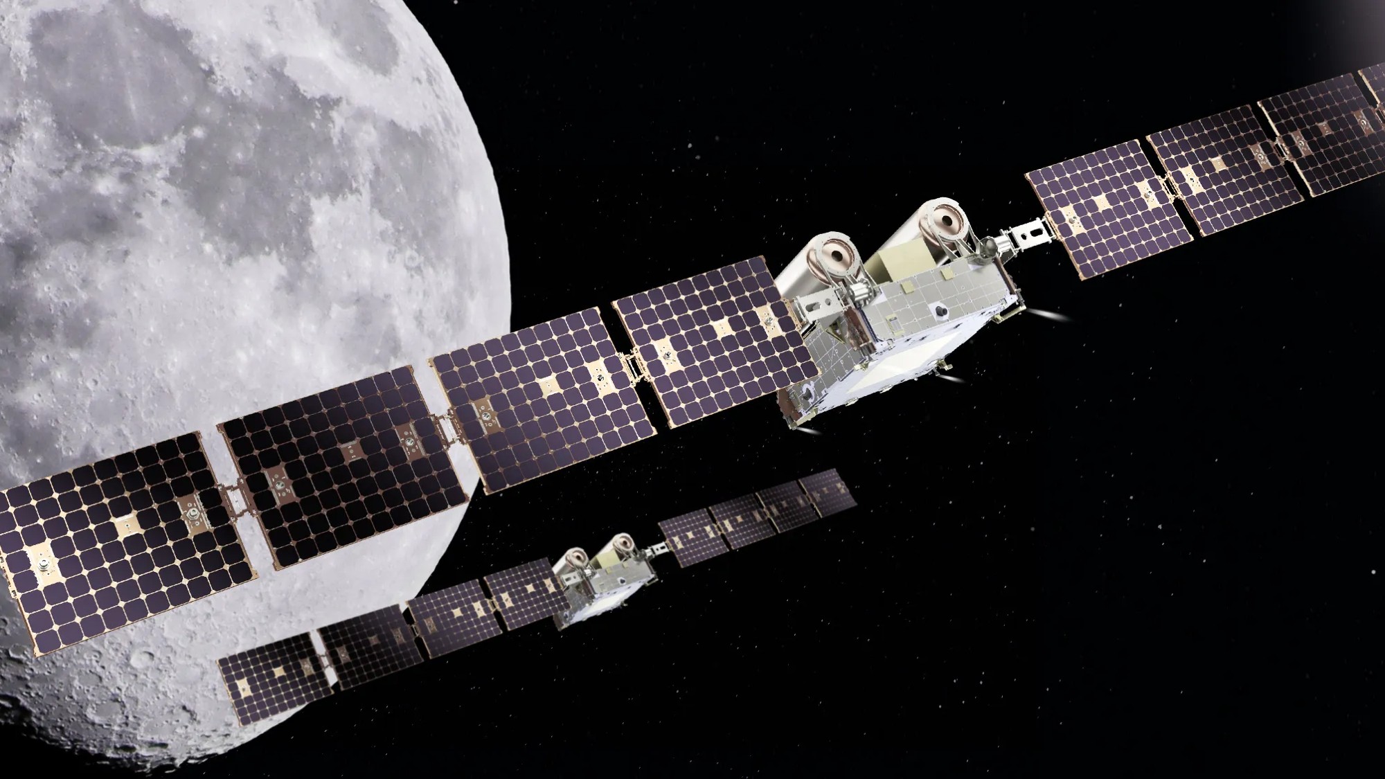
In August 2026, NASA announced that it had delivered the NavCube3-mini navigation payload to Intuitive Machines for integration into Altus-1, the company's first lunar relay satellite. NASA says the lunar relay is being developed to provide communication and navigation services for astronauts and rovers operating around the agency's future Moon Base.
This development is important because it points toward something that could eventually resemble a GPS-like navigation infrastructure around the Moon.
The Moon does not have a conventional GPS constellation like Earth.
Instead, future missions could use dedicated lunar navigation satellites, relay spacecraft, onboard sensors and Earth-based systems working together.
The result could be a completely new navigation ecosystem beyond Earth.
Why Does the Moon Need Its Own Navigation System?
On Earth, GPS is everywhere.
A GPS receiver can listen to signals from multiple satellites and calculate its location.
The Moon is different.
There is no GPS constellation orbiting the Moon specifically for lunar users.
Earth's GPS signals can sometimes be detected far beyond Earth, but their availability and geometry are not designed for routine lunar navigation.
As lunar activity increases, depending entirely on Earth-based navigation becomes increasingly complicated.
A future lunar environment could contain:
- Astronauts
- Rovers
- Cargo landers
- Science instruments
- Communication satellites
- Navigation satellites
- Lunar bases
- Commercial spacecraft
All of these systems need accurate positioning.
That creates a strong reason to develop dedicated lunar PNT infrastructure.
What Is PNT?
PNT stands for:
Positioning, Navigation and Timing.
These three capabilities are fundamental to modern technology.
Positioning
Determining where something is located.
Navigation
Determining how to move from one location to another.
Timing
Maintaining accurate time for synchronization and operations.
GPS provides all three capabilities on Earth.
NASA's lunar technology aims to create similar capabilities in the lunar environment.
NASA’s NavCube3-mini Is Part of the Solution
NASA delivered the NavCube3-mini payload in July 2026 for integration into Intuitive Machines' Altus-1 lunar relay spacecraft.
The technology is designed to support future lunar communication and navigation services.
This is significant because a lunar relay satellite can act as an important part of the infrastructure connecting spacecraft, astronauts and ground systems.
Instead of every lunar vehicle communicating independently with Earth, relay satellites can help create a local lunar network.
That could make lunar operations more efficient.
What Is a Lunar Relay Satellite?
A relay satellite acts as a communication bridge.
Imagine a rover operating on the far side or in an area where direct communication with Earth is difficult.
A relay satellite positioned appropriately around the Moon could receive information from the rover and send it onward.
The same infrastructure can potentially support navigation services.
That creates a powerful combination:
Communication + Navigation
in one lunar network.
Why Navigation Is Different on the Moon
The Moon has a very different environment from Earth.
There are:
- No conventional roads
- No cellular networks
- No terrestrial navigation towers
- No global GPS constellation
- Extreme terrain
- Large numbers of craters
- Long periods of darkness
- Difficult communication conditions
A rover cannot simply open a navigation app and receive a GPS location like a car on Earth.
Instead, lunar spacecraft need specialized navigation systems.
How Could Lunar GPS Work?
A future lunar navigation system could use multiple satellites orbiting the Moon.
These satellites could broadcast precise timing and navigation signals.
A lunar rover could receive signals from several satellites.
The rover's navigation computer could then calculate its location.
The basic principle would be similar to GPS on Earth.
The major difference would be the environment.
Instead of:
Earth + GPS satellites
the system could become:
Moon + Lunar Navigation Satellites
NASA Is Moving Toward a Lunar Communications Architecture
NASA's broader lunar strategy includes building communication infrastructure around the Moon.
The agency's recent NavCube3-mini development is part of this effort.
NASA says lunar relays are designed to provide communications and navigation for astronauts and rovers operating at the agency's future Moon Base.
This suggests that future lunar exploration will increasingly depend on infrastructure rather than isolated missions.
Why Future Moon Bases Need Navigation
A permanent or semi-permanent lunar base would create an entirely new navigation environment.
Imagine astronauts traveling several kilometers away from their base.
They could use:
- Rovers
- Cargo vehicles
- Autonomous robots
- Science instruments
Every vehicle needs to know where it is.
A reliable navigation network would make these operations safer and more efficient.
Lunar Rovers Could Benefit the Most
Rovers are likely to become major users of lunar navigation.
A rover could use navigation signals to determine:
- Its location
- Distance from the base
- Route
- Speed
- Direction
- Position relative to scientific targets
It could also combine satellite navigation with cameras, inertial sensors and terrain maps.
This creates a multi-layer navigation system.
GPS Alone Would Not Be Enough
Even if a lunar navigation constellation is created, future vehicles probably will not depend on it exclusively.
A rover could combine:
Lunar navigation signals
with
Inertial navigation
with
Cameras
with
Terrain maps
with
Laser measurements
This is called sensor fusion.
The more independent sources available, the more resilient the navigation system can become.
Optical Navigation Could Help Lunar Vehicles
Lunar vehicles can use cameras to understand their environment.
The Moon has many recognizable terrain features.
These include:
- Craters
- Mountains
- Ridges
- Valleys
- Rocks
- Surface patterns
A rover can compare what its cameras see with detailed lunar maps.
This can provide an additional position estimate.
AI Could Improve Lunar Navigation
Artificial intelligence could become another important component.
An AI system could process information from:
- Navigation satellites
- Cameras
- Inertial sensors
- Terrain maps
- Lidar
- Radar
The system could then calculate the most likely location.
If one navigation source becomes unreliable, the system could rely more heavily on other sources.
This could be particularly important in challenging lunar environments.
NASA Is Already Demonstrating Autonomous Navigation in Space
The lunar navigation effort is part of a broader NASA trend toward autonomous spacecraft.
On August 17, 2026, NASA announced that its Starling mission had demonstrated GPS-independent navigation using onboard optical observations of objects in space.
The technology, called FALCON, allows a spacecraft to determine its position by referencing objects in space rather than relying entirely on a navigation network.
NASA says this technology could eventually support:
- Lunar satellite swarms
- Distributed science missions
- Human exploration
- Space traffic management
- Collision avoidance
This is an important development for the future of lunar navigation.
What Is NASA FALCON?
FALCON stands for:
Fast Autonomous Lost-in-space Catalog-based Optical Navigation.
The system uses optical observations and an onboard catalog to support autonomous navigation.
Instead of always asking Earth:
“Where am I?”
the spacecraft can use its own sensors to help determine its position.
This could become extremely useful around the Moon and in deep space.
Combining FALCON With Lunar Navigation
The most interesting future possibility is combining technologies.
A lunar spacecraft could potentially use:
- Lunar navigation satellites
- Optical navigation
- Star tracking
- Inertial sensors
- Earth communication
- AI
This would create a resilient navigation architecture.
If one system becomes unavailable, another can continue providing information.
Why Autonomous Navigation Matters
Communication with Earth takes time.
For the Moon, the delay is relatively small.
But as missions travel farther away, communication delays become increasingly significant.
Mars is a good example.
A spacecraft cannot always wait for Earth to analyze every navigation problem.
Autonomous navigation allows spacecraft to make certain decisions locally.
The Moon Could Become a Testbed for Future Navigation
The Moon is close enough to Earth to support regular communication but far enough away to create new navigation challenges.
This makes it an ideal environment for testing technologies that could eventually be used in deeper space.
NASA could develop and test:
- Lunar PNT
- Autonomous navigation
- Satellite swarms
- Relay networks
- AI navigation
- Space traffic management
These technologies could later support Mars and other destinations.
NASA’s Lunar Navigation Technology Could Support Commercial Companies
The future lunar economy is expected to involve more than government missions.
Commercial companies are increasingly participating in lunar missions.
Potential future users of lunar navigation infrastructure include:
- Commercial landers
- Private rovers
- Science missions
- Mining-related research
- Communications companies
- Cargo services
- Tourism-related missions
A shared navigation infrastructure could reduce the complexity of individual missions.
Why a Shared Lunar Network Makes Sense
Imagine every company having to build its own navigation satellites.
That would be expensive and inefficient.
A shared lunar navigation network could allow multiple missions to use common infrastructure.
This is similar to how GPS supports millions of users on Earth.
A lunar equivalent could eventually become a foundational service.
The Role of Commercial Lunar Relay Satellites
NASA's partnership with commercial companies is important here.
The agency delivered NavCube3-mini to Intuitive Machines for integration into Altus-1.
This illustrates a broader strategy:
NASA develops technology + commercial companies provide spacecraft and services.
That model could accelerate lunar infrastructure development.
How Lunar Navigation Could Help Astronauts
Astronauts could carry navigation equipment that communicates with lunar infrastructure.
Instead of relying exclusively on Earth communication, they could receive local navigation information.
This could improve:
- Surface exploration
- Rover operations
- Emergency response
- Scientific research
- Base construction
Precise positioning becomes particularly important when astronauts move far away from their base.
Emergency Navigation on the Moon
Safety is one of the strongest arguments for lunar navigation infrastructure.
Suppose an astronaut or rover becomes separated from the main base.
A navigation system could help determine:
- Exact location
- Distance to base
- Available routes
- Nearby terrain hazards
A reliable communication and navigation network could therefore become a critical safety system.
Lunar Navigation and Scientific Research
Scientists could also benefit.
Multiple instruments operating at different locations need precise positioning.
For example, researchers might want to compare measurements collected by several lunar instruments.
Knowing the exact location of each instrument makes scientific analysis more accurate.
NASA's autonomous navigation work specifically notes that precise spacecraft positioning can be important when multiple spacecraft collect measurements from different points in space.
Spacecraft Swarms Could Change Lunar Science
Instead of one large satellite, NASA could eventually deploy multiple smaller satellites.
These satellites could form a coordinated swarm.
A swarm could:
- Monitor the Moon
- Provide communications
- Provide navigation
- Observe the environment
- Track spacecraft
- Support scientific experiments
Autonomous navigation becomes especially important when many spacecraft operate together.
GPS Technology Is Evolving Beyond Earth
For decades, the phrase "GPS technology" mostly meant Earth navigation.
That is changing.
The basic ideas behind GPS—precise timing, satellite signals and position determination—are now being adapted for space.
Future systems could create:
Earth PNT
and
Lunar PNT
with different architectures.
NASA’s GRITSS Mission Could Also Improve Positioning Technology
NASA launched another important navigation-related CubeSat in July 2026.
The GRITSS satellite is designed to connect three independent measurement systems:
- Very Long Baseline Interferometry
- GPS receivers
- Satellite Laser Ranging
NASA says the goal is to demonstrate a technique that could contribute to more accurate mapping and positioning of Earth.
This is important because navigation technology depends on extremely accurate reference systems.
Why Earth-Based GPS Still Matters to Lunar Navigation
Even when spacecraft operate near the Moon, Earth remains an important reference.
Ground stations can track spacecraft.
Earth-based navigation systems can provide additional information.
Future lunar systems may therefore combine:
Earth tracking + lunar navigation + autonomous sensors.
This layered architecture could provide much greater reliability.
The Future Lunar Navigation System Could Look Like This
Imagine a lunar rover in the future.
It receives signals from several lunar navigation satellites.
At the same time, its cameras identify nearby craters.
Its inertial sensors measure movement.
A laser system measures terrain.
AI software combines all the information.
The rover calculates:
Position: 12.4 meters from expected location
Navigation confidence: High
Destination: Lunar Base
Route: Safe
This is the type of autonomous navigation environment NASA's technology developments are moving toward.
Why Timing Is Important on the Moon
Navigation is not only about location.
Timing is equally important.
Navigation satellites need extremely accurate clocks.
Receivers calculate their position by comparing signal timing.
That means lunar navigation satellites would require precise timing systems.
This is one of the reasons GPS technology is as much a timing technology as it is a positioning technology.
Lunar Navigation Could Support Autonomous Robots
Future lunar bases could contain many robots.
For example:
- Construction robots
- Mining research robots
- Scientific rovers
- Cargo vehicles
- Inspection robots
All of them could use the same navigation infrastructure.
This could make a lunar base more automated.
Navigation Will Be Critical for Lunar Construction
Building infrastructure on the Moon will require precise positioning.
Robotic systems may need to place:
- Solar panels
- Communication equipment
- Landing infrastructure
- Habitats
- Scientific instruments
A navigation network could help coordinate these operations.
The Challenge of Lunar Terrain
The Moon's terrain is extremely uneven.
There are craters, slopes, rocks and areas with limited visibility.
A GPS-like system alone cannot solve every problem.
Vehicles will still need local sensing.
This makes sensor fusion particularly important.
Shadowed Regions Could Be Difficult
Some lunar regions remain permanently or semi-permanently shadowed.
These environments can create difficult conditions for cameras and solar-powered equipment.
Navigation systems need to continue operating even when visual information is limited.
This is another reason why multiple navigation sources are necessary.
Lunar Navigation Could Eventually Support Mars
The Moon is not the final destination.
NASA and other organizations are interested in deeper-space exploration.
Technologies developed for lunar navigation could eventually be adapted for:
- Mars
- Asteroids
- Deep-space spacecraft
- Planetary science missions
A lunar navigation network could therefore become a stepping stone toward an interplanetary navigation architecture.
What Happens When GPS Is Not Available?
The key lesson from NASA's current research is simple:
Navigation should not depend on one system.
On Earth, GPS can be combined with:
- Inertial sensors
- 5G
- Ground-based signals
- Cameras
- Maps
In space, spacecraft can use:
- Star trackers
- Optical navigation
- Planetary observations
- Inertial systems
- Satellite networks
- Ground tracking
This creates resilience.
NASA Is Building a Multi-Layer Navigation Future
The different NASA projects announced in 2026 show how navigation is becoming increasingly sophisticated.
The NavCube3-mini effort is aimed at lunar communication and navigation infrastructure.
The Starling FALCON demonstration explores GPS-independent spacecraft navigation.
The GRITSS mission is testing a way to connect independent measurement systems for more precise global positioning.
Together, these developments point toward a broader trend:
Navigation is becoming distributed, autonomous and multi-source.
What Could Lunar GPS Mean for Consumers?
At first, lunar navigation may sound unrelated to everyday technology.
But space technologies often eventually influence consumer products.
GPS itself began as a government technology.
Today it powers:
- Smartphones
- Ride-sharing
- Fitness devices
- Vehicle navigation
- Logistics
- Agriculture
- Emergency services
Future autonomous navigation technologies could similarly find applications on Earth.
Possible Earth Applications
Technologies developed for space could eventually improve:
- Autonomous vehicles
- Drones
- Robotics
- GPS-denied navigation
- Disaster response
- Industrial automation
For example, an autonomous robot in a warehouse could use optical navigation and sensor fusion concepts originally developed for spacecraft.
Why This Is Important for the U.S. Technology Industry
The development of lunar navigation technology is also creating opportunities for American technology companies.
Potential markets include:
- Satellite hardware
- Navigation chips
- AI software
- Optical sensors
- Communications
- Space robotics
- Autonomous systems
- Timing technology
NASA's partnership with commercial companies demonstrates how government-funded research can move toward commercial applications.
The Future of GPS Is Bigger Than GPS
The term GPS may eventually become too narrow to describe modern navigation.
Instead, we could have a broader ecosystem of:
GNSS
PNT
Autonomous navigation
Optical navigation
Lunar navigation
Deep-space navigation
Each technology will have a specific role.
Frequently Asked Questions
Does the Moon have GPS?
The Moon does not currently have a dedicated GPS constellation like Earth. NASA and its partners are developing communication and navigation infrastructure intended to support future lunar operations.
What is NASA’s NavCube3-mini?
NavCube3-mini is a NASA navigation payload being integrated into Intuitive Machines' Altus-1 lunar relay satellite. NASA says the lunar relay is intended to provide communications and navigation services for future lunar users.
Can GPS work on the Moon?
GPS signals can sometimes be detected beyond Earth's surface, but GPS was not designed as a dedicated lunar navigation system. Future lunar missions need more specialized navigation infrastructure.
What is lunar navigation?
Lunar navigation is the technology used to determine the position, direction and movement of spacecraft, rovers and astronauts operating around or on the Moon.
Will the Moon get a GPS-like system?
A dedicated lunar positioning and navigation architecture is increasingly being developed through lunar relay satellites and other technologies. NASA's current programs are steps toward that broader capability.
What is NASA Starling?
Starling is a NASA small-satellite mission testing autonomous spacecraft technologies. Its extended mission has demonstrated GPS-independent optical navigation.
What is FALCON?
FALCON stands for Fast Autonomous Lost-in-space Catalog-based Optical Navigation. It is designed to help spacecraft determine their position using optical observations and onboard object information.
Can AI navigate a spacecraft?
AI can assist with navigation by processing sensor information and helping determine a spacecraft's position, but it still relies on physical measurements from sensors and navigation systems.
Why does the Moon need navigation satellites?
Future lunar operations will involve many spacecraft, rovers and astronauts. Dedicated navigation satellites could provide a shared positioning and timing infrastructure for these users.
Could lunar navigation technology help Mars missions?
Yes. Technologies developed for autonomous lunar navigation could potentially be adapted for future Mars and deep-space missions.
Conclusion
NASA's latest lunar navigation developments show that the future of GPS technology is moving far beyond Earth.
For decades, GPS has provided the foundation for modern navigation on our planet.
Now NASA is working toward a future in which similar positioning, navigation and timing capabilities can support astronauts, spacecraft and robots on the Moon.
The delivery of NASA's NavCube3-mini payload for integration into Intuitive Machines' Altus-1 lunar relay satellite represents an important step in that direction. NASA says the lunar relay is being developed to provide communication and navigation services for astronauts and rovers operating at the agency's future Moon Base.
At the same time, NASA's Starling mission has demonstrated GPS-independent navigation through the FALCON experiment, showing how spacecraft can use optical observations of objects in space to help determine their own positions.
These developments suggest that future navigation will not be based on one technology.
Instead, lunar spacecraft could combine:
Navigation satellites + optical sensors + star trackers + inertial systems + AI + Earth-based tracking.
This approach could provide the reliability needed for increasingly complex lunar missions.
The importance goes beyond the Moon.
The same technologies could eventually support Mars exploration, autonomous spacecraft, satellite swarms and deep-space science missions.
And just as GPS eventually transformed everyday life on Earth, lunar navigation technology could eventually create entirely new commercial opportunities.
The biggest change is therefore not simply that NASA wants to put GPS on the Moon.
The bigger change is that navigation itself is becoming autonomous.
Future spacecraft may not always need to ask Earth where they are.
They may be able to look at the stars, observe other spacecraft, analyze their surroundings and calculate their own position.
That could be one of the most important steps toward a future where humans and robots can operate independently beyond Earth.
The next generation of GPS technology may not just connect people on Earth—it could help build the navigation infrastructure for humanity's expansion into space.











No responses yet