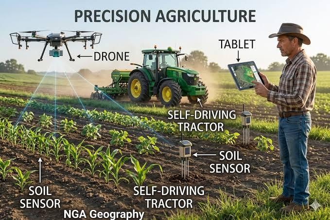

Introduction: The Future of American Farming Is Becoming More Intelligent
Agriculture has always depended on a combination of experience, weather conditions, soil quality, and careful planning. For generations, American farmers have relied on their knowledge of the land to decide when to plant crops, apply fertilizer, irrigate fields, and harvest their produce. However, modern farming is becoming increasingly data-driven as new technologies give farmers more detailed information about their fields.
In 2026, precision agriculture is an important part of this transformation. It combines GPS guidance, satellite imagery, agricultural drones, connected sensors, artificial intelligence, automated machinery, and data analytics to help farmers make more informed decisions.
Instead of treating an entire field as if every section has identical needs, precision agriculture allows farmers to identify differences in soil conditions, moisture levels, crop health, and nutrient availability. They can then adjust certain farming activities according to the specific conditions of different areas.
For example, one section of a cornfield may need additional nitrogen, while another already contains sufficient nutrients. A traditional approach might apply fertilizer uniformly across the field. A precision farming system can use soil measurements, field maps, and variable-rate equipment to apply different amounts where appropriate.
The potential benefits include better resource management, improved operational efficiency, reduced waste, and more accurate monitoring of crop conditions. The US Department of Agriculture’s National Institute of Food and Agriculture explains how GPS, sensors, robotics, and information technology are helping modern agricultural operations become more efficient.
Nevertheless, precision agriculture is not a guaranteed shortcut to higher profits. Equipment can be expensive, connectivity can be unreliable in rural locations, and interpreting agricultural data requires knowledge and experience.
What Is Precision Agriculture Technology?
Precision agriculture is a farming approach that uses detailed information about location, soil, weather, crops, and equipment to guide agricultural decisions.
The central idea is that different parts of a field may require different treatments. By collecting and analyzing information at a more detailed level, farmers can make adjustments that reflect actual conditions instead of relying exclusively on uniform applications.
Precision agriculture can involve simple technologies, such as GPS-guided tractors, or more advanced systems combining sensors, satellite imagery, AI analysis, and automated machinery.
The Main Technologies Used in Precision Farming
1. GPS guidance systems
GPS helps agricultural machinery determine its location within a field. Farmers can use GPS-guided tractors and harvesters to follow planned paths, map field boundaries, and reduce unnecessary overlap between machinery passes.
2. Soil and crop sensors
Sensors can measure soil moisture, temperature, electrical conductivity, and other relevant conditions. Depending on the system, crop sensors may also estimate plant characteristics or identify signs of stress.
3. Satellite imagery
Satellite images can help farmers monitor crop development, examine field variability, and identify areas that may need closer inspection.
4. Agricultural drones
Drones equipped with cameras and specialized sensors can collect detailed images of crops. These images may help identify uneven growth, irrigation problems, pest damage, or other issues requiring investigation.
5. Artificial intelligence and data analytics
AI and analytical software can combine multiple information sources to identify patterns and support decisions about irrigation, fertilization, spraying, and harvesting.
6. Variable-rate application equipment
Variable-rate systems adjust the amount of fertilizer, seed, or another agricultural input applied to different parts of a field. These adjustments can be based on field maps, sensor readings, agronomic recommendations, and equipment capabilities.
7. Automated agricultural machinery
Robotic and automated equipment can support selected tasks such as navigation, targeted spraying, monitoring, and certain harvesting activities.
These technologies can be used independently or combined into a larger system. A farm does not need every available tool to benefit from precision agriculture.
Why Precision Agriculture Matters in the USA in 2026
American agriculture operates across a wide range of environments, from large corn and soybean farms in the Midwest to orchards in California, cotton fields in the South, and livestock operations across the Great Plains.
These farms face different challenges, including water availability, fertilizer prices, labor requirements, weather variability, soil conditions, and changing market demands.
Precision agriculture offers a way to manage some of these challenges through more detailed information and targeted decisions.
Better Management of Farm Inputs
Seeds, fertilizer, pesticides, fuel, and irrigation water represent important operating expenses. Applying these resources more accurately may help farmers avoid unnecessary use.
The US Government Accountability Office reviewed precision agriculture in its report, Precision Agriculture: Benefits and Challenges for Technology Adoption and Use. The report discusses potential efficiency and environmental benefits while highlighting barriers such as high upfront costs and technological complexity.
More Detailed Crop Monitoring
Farmers cannot always inspect every section of a large field regularly. Satellite imagery, sensors, and drones can help identify areas that deserve closer attention.
These tools do not necessarily explain the cause of a problem automatically. Instead, they can help farmers narrow down where an inspection or additional testing may be useful.
Improving Operational Planning
GPS guidance, digital field maps, and equipment data can help farm operators plan machinery routes and coordinate planting, spraying, and harvesting activities.
Over time, historical records can also help farmers compare field performance across growing seasons.
Responding to Environmental Conditions
Weather conditions and water availability can change rapidly. Precision tools can help farmers identify differences in soil moisture, monitor crop stress, and adjust irrigation schedules where suitable.
The value of these systems depends on reliable measurements and sound agronomic decisions. Technology supports farming expertise; it does not replace it.
GPS Technology: The Foundation of Precision Farming
GPS is one of the most established technologies used in precision agriculture. It provides positioning information that helps farmers and agricultural machines identify where work is taking place.
Without accurate location information, it would be much harder to apply different treatments to specific sections of a field or return to the same location for repeat measurements.
GPS-Guided Tractors and Harvesters
Modern guidance systems can help machinery follow planned paths across agricultural fields. Depending on the equipment and positioning service, the system may provide basic guidance or much more precise steering.
This can reduce unnecessary overlaps, help operators work more consistently, and support efficient use of fuel and other inputs.
Some systems also record where machinery has planted seeds, applied fertilizer, or harvested crops. These records can later be compared with field performance.
Field Mapping and Soil Sampling
GPS helps farmers map field boundaries, mark sampling locations, and identify areas that have different soil or crop characteristics.
For example, a farmer can collect soil samples from several locations and associate each sample with its geographic position. The results can then be used to develop a more detailed nutrient management plan.
Repeated sampling can help the farmer compare conditions over time, although sampling quality and appropriate interpretation remain essential.
Variable-Rate Farming
GPS positioning can work with variable-rate equipment to apply different quantities of an agricultural input in different areas.
A prescription map may identify where a particular nutrient is needed and specify the intended application rate. Compatible machinery can use that map to adjust its operation as it moves through the field.
The US government’s GPS.gov precision agriculture guide explains how GPS-based positioning supports field mapping, equipment guidance, and more targeted agricultural operations.
Artificial Intelligence in American Agriculture
Artificial intelligence is creating new ways to interpret agricultural information. Farms can generate large quantities of data through soil sensors, weather stations, machinery, satellites, and crop-monitoring systems.
AI tools can help organize this information and identify patterns that may be difficult to detect through manual observation alone.
Detecting Crop Stress
Images collected by satellites or drones may reveal differences in crop appearance, canopy development, or temperature.
AI systems can analyze these images to flag unusual areas. Farmers can then inspect the affected sections to determine whether the cause is related to water availability, pests, disease, nutrients, or another factor.
An image alone does not always identify the precise cause. Reliable diagnosis may require field inspections, laboratory tests, or advice from an agricultural specialist.
Supporting Fertilizer Decisions
AI-based tools can combine soil information, crop observations, weather conditions, and historical field records to help farmers assess nutrient requirements.
Such systems may support decisions about where and when fertilizer should be applied. Their recommendations should be checked against local agronomic guidance and the actual requirements of the crop.
Improving Harvest Planning
Crop monitoring and historical data can help farmers estimate how crops are developing and identify areas that may require attention before harvest.
More accurate information can assist with labor scheduling, equipment allocation, storage planning, and transportation arrangements.
However, weather, crop disease, equipment availability, and other variables can still affect the final result.
Research Into Plant-Based Monitoring
A notable example of US agricultural research appeared in a USDA National Institute of Food and Agriculture report published on February 9, 2026.
The report, New Technology Lets Plants Tell Farmers When They Are Thirsty, describes research combining sensors, machine learning, drone imagery, satellite information, and crop-growth models to support more targeted irrigation and nutrient management.
The researchers are developing a digital representation of a field that can integrate changing information and provide recommendations about where additional resources may be needed.
This work illustrates how precision agriculture is evolving beyond simply collecting data. The larger goal is to convert measurements into practical guidance that farmers can use in the field.
Agricultural Drones and Satellite Monitoring
Agricultural drones and satellites provide different but complementary ways to observe crops.
Satellites can cover extensive areas and support regular monitoring, while drones can collect detailed images over selected fields when conditions and regulations permit.
How Drones Help Farmers
A drone can carry visible-light cameras and, depending on the equipment, multispectral or thermal sensors.
These instruments may help reveal differences in plant development, vegetation patterns, temperature, or other crop characteristics.
Farmers can use the resulting information to identify areas for further inspection rather than walking through every section of a large field without guidance.
Targeted Spraying
Some agricultural drone systems and other precision spraying technologies are designed to target specific locations.
When properly configured and legally operated, targeted systems may reduce unnecessary applications by treating identified problem areas rather than applying the same treatment uniformly.
Actual performance depends on crop type, sensor accuracy, weather, equipment design, and the quality of the treatment decision.
Satellite-Based Crop Monitoring
Satellite imagery can help farmers monitor broad changes in vegetation and crop conditions over time.
Comparing images from different dates may reveal patterns associated with uneven growth or possible water stress. Cloud cover, image resolution, revisit intervals, and the characteristics of the crop can affect how useful the information is.
Regulations and Safe Operation
In the United States, agricultural drone operations must comply with applicable Federal Aviation Administration requirements. Additional rules may apply depending on whether the drone is used for imaging, spraying, or other commercial activities.
Farmers should check the relevant FAA drone regulations and guidance before conducting commercial operations.
Smart Irrigation and Water Conservation
Water management is an important challenge for many American farms. Some regions experience seasonal drought, declining groundwater availability, or restrictions on water use, while other areas face different challenges related to rainfall and drainage.
Precision irrigation combines measurements and planning tools to help farmers decide when and where water should be applied.
Soil Moisture Sensors
Soil moisture sensors measure water conditions at selected locations and depths. Farmers can use these readings to assess whether the soil is becoming too dry or whether irrigation can be delayed.
A single sensor may not represent the conditions across an entire field, particularly when soil types and elevations vary. Sensor placement and calibration therefore matter.
Weather-Based Irrigation Planning
Weather stations and forecast information can help farmers estimate crop water requirements and plan irrigation around expected conditions.
For example, expected rainfall may influence whether irrigation is necessary immediately or can be postponed. Crop growth stage and local soil conditions must also be considered.
AI-Assisted Irrigation
Advanced systems can combine soil measurements, crop imagery, weather information, and crop models to generate irrigation recommendations.
In some systems, farmers receive alerts or recommendations for particular zones. Other setups may connect with automated irrigation equipment, subject to suitable safeguards and configuration.
Why Better Water Management Matters
Applying water more accurately may help farmers avoid unnecessary pumping and improve the timing of irrigation. It can also reduce some of the problems associated with overwatering.
However, the amount of water saved depends on the starting conditions, the crop, the irrigation method, and how the technology is used.
Precision Fertilizer and Nutrient Management
Fertilizer is essential for many agricultural systems, but applying more than crops can use may increase expenses and contribute to nutrient losses.
Precision nutrient management seeks to match fertilizer applications with crop needs, soil conditions, and the timing of nutrient uptake.
Soil Testing and Digital Field Maps
Soil testing provides information about nutrient availability and other characteristics that influence crop growth.
When test results are associated with geographic locations, farmers can develop maps that show how soil conditions vary across a field.
These maps may support decisions about fertilizer rates, but they should be interpreted alongside crop requirements, historical yields, and appropriate agronomic guidance.
Variable-Rate Fertilizer Applications
Variable-rate equipment can adjust fertilizer application according to a prescription map or sensor input.
For example, different zones within a field may receive different nitrogen rates based on soil tests and crop requirements.
The purpose is not necessarily to use the smallest possible quantity everywhere. It is to apply an appropriate amount in the right location and at the right time.
Environmental Benefits
Excess nutrients can move from fields into surface water and groundwater. Better nutrient management can help reduce avoidable losses when it is implemented correctly.
The US Environmental Protection Agency explains how appropriate fertilizer management and precision agriculture practices can help reduce nutrient pollution. More information is available through the EPA’s agriculture nutrient management guidance.
The effectiveness of a particular practice depends on local soil conditions, rainfall, crop needs, and farm management decisions.
Precision Agriculture Across Major US Farming Regions
Precision agriculture can be adapted to different crops and environments. Its practical use varies depending on farm size, equipment, local infrastructure, and the production system.
Midwest: Corn and Soybean Production
States such as Iowa, Illinois, and Nebraska have substantial corn and soybean production.
Precision tools can support planting guidance, fertilizer management, yield monitoring, and field mapping. Farmers may compare yield maps from different seasons to investigate recurring patterns and improve future management decisions.
Large fields can make GPS guidance and variable-rate applications particularly useful, although investment costs and farm-specific conditions still influence adoption.
California: Specialty Crops and Irrigation
California produces a wide range of specialty crops, including fruits, nuts, vegetables, and other high-value agricultural products.
Precision irrigation, moisture sensors, and crop monitoring can help growers manage water and identify differences between sections of an orchard or field.
The value of these tools varies with the crop, soil, irrigation system, and the cost of installation and maintenance.
Great Plains: Large-Scale Crop Operations
Agricultural operations across parts of the Great Plains may benefit from GPS guidance, machinery data, satellite imagery, and field-level analysis.
These tools can support planning across large areas, particularly when growers need to coordinate planting, spraying, and harvesting over multiple fields.
Connectivity limitations in some rural areas can influence how much data is processed locally versus through online services.
Southern States: Cotton, Rice, and Other Crops
Precision agriculture can support a variety of southern farming systems. Depending on the crop and location, applications may include targeted fertilizer management, pest monitoring, water management, and equipment guidance.
Technology selection should reflect local growing conditions rather than assuming that one system will work equally well across every crop.
Benefits of Precision Agriculture for American Farmers
Precision agriculture can deliver several practical advantages when it is suited to the farm’s needs.
Improved input efficiency: Targeted applications may reduce unnecessary use of fertilizer, water, fuel, and other resources.
Better field visibility: Sensors and imagery can help farmers identify areas that deserve closer attention.
More consistent machinery operation: GPS guidance can reduce unnecessary overlap and support repeatable field operations.
Improved decision-making: Historical records and current measurements can help farmers compare management strategies.
Potential environmental benefits: More accurate nutrient and chemical applications can help reduce avoidable losses when combined with sound management practices.
Support for labor planning: Automation and monitoring tools may reduce the time required for selected repetitive tasks.
Better recordkeeping: Digital maps and equipment records can help farms document field operations and evaluate results over time.
These benefits are not automatic. Farmers should compare actual operating results with the costs of acquiring, integrating, and maintaining the technology.
Challenges Facing Precision Agriculture Adoption in the USA
Despite its potential, precision agriculture is not equally accessible to every farm.
High Upfront Costs
GPS guidance, specialized sensors, drones, software subscriptions, and variable-rate machinery can require substantial investment.
Smaller farms may find it difficult to justify the cost if the technology offers only modest savings or if the payback period is uncertain.
Some farms can begin with lower-cost services, shared equipment, or a limited pilot rather than purchasing a complete system immediately.
Rural Connectivity Limitations
Some agricultural operations are located in areas with limited broadband or inconsistent mobile connectivity.
This can affect the transfer of imagery, remote monitoring, and cloud-based analytics. Systems that can collect information locally and synchronize it later may be useful where continuous connectivity is unavailable.
Data Ownership and Compatibility
Agricultural equipment and software may store data in different formats. Farmers can face difficulties moving information between platforms or using historical records with equipment from another manufacturer.
Before purchasing a system, farmers should review data export options, compatibility, subscription terms, and who can access the information generated on the farm.
Technical Skills and Training
Farmers need to understand what measurements mean and how to interpret recommendations.
A sensor may show a difference in crop conditions without identifying the cause. Effective use often requires agronomic knowledge, calibration, field verification, and experience with the particular system.
Reliability and Maintenance
Sensors can fail, batteries can run down, cameras can become dirty, and equipment can lose connectivity.
Precision systems need regular maintenance and a plan for responding to missing or unreliable data. Farmers should avoid making major decisions based on measurements that have not been checked for quality.
Unequal Adoption Across Farm Sizes
The US Government Accountability Office has highlighted differences in access to precision agriculture technologies and the financial and technical barriers that can limit adoption.
USDA Economic Research Service analysis also shows that adoption varies by farm size and technology type. For example, its precision agriculture adoption analysis reported that guidance autosteering systems were used by 52% of midsize farms and 70% of large-scale crop-producing farms in 2023.
These figures describe particular farm groups and a specific year; they should not be interpreted as the adoption rate for all US farms or as a measurement of adoption in 2026.
How Small and Medium-Sized Farms Can Get Started
Farmers do not need to invest in every available technology at once. A phased approach can help determine whether a particular tool produces meaningful results.
Step 1: Identify a Specific Problem
Begin with an issue that can be measured, such as uneven irrigation, excessive fertilizer expenses, machinery overlap, or recurring crop stress.
A clear problem makes it easier to select an appropriate tool.
Step 2: Review Existing Equipment
Check whether current tractors, irrigation systems, or farm management software already provide useful data or support basic precision features.
An existing system may offer more value after configuration or training, without requiring a complete replacement.
Step 3: Choose One Practical Technology
A farm might start with soil testing and field maps, GPS guidance, a moisture sensor, or a crop-monitoring service.
The best starting point depends on the crop, farm size, operating budget, and the problem being addressed.
Step 4: Establish a Baseline
Record current costs, yields, input quantities, labor time, or other relevant measurements before introducing the new system.
Without a baseline, it can be difficult to determine whether the technology actually improved performance.
Step 5: Test the Technology on a Limited Area
Where practical, use the new approach on a selected field or section before expanding it across the entire operation.
Compare the results with similar areas while accounting for differences in soil, weather, and crop conditions.
Step 6: Evaluate the Financial Return
Consider the cost of equipment, software, maintenance, training, and any required connectivity.
Compare these costs with the measured improvements. If the results are promising and repeatable, the farm can consider expanding the system.
Step 7: Protect and Maintain Farm Data
Use appropriate account security, keep software updated, and understand the provider’s data policies.
Farmers should retain access to important records and avoid depending entirely on a system that makes it difficult to export their own information.
The Future of Precision Agriculture Technology in the USA
Precision agriculture is likely to evolve as sensing systems, satellite services, robotics, AI, and agricultural software improve.
Future progress will depend on whether these tools can deliver useful results at costs that make sense for farms of different sizes.
More Targeted Agricultural Robots
Robots and automated machines may increasingly support tasks such as crop monitoring, mechanical weeding, targeted spraying, and selected harvesting activities.
The most useful applications will depend on whether the technology can operate reliably under real farm conditions and justify its cost.
More Integrated Data Systems
Farmers may increasingly combine machinery records, field maps, soil tests, weather observations, and crop imagery within connected farm management platforms.
Better integration could make it easier to understand how decisions affect performance across different growing seasons.
AI-Assisted Farm Management
AI systems may help farmers interpret complex information, compare possible treatments, and prioritize inspections.
For these systems to be useful, recommendations need to be transparent enough to evaluate, relevant to local conditions, and grounded in reliable data.
Digital Twins of Agricultural Fields
Digital twins can combine field information, sensor readings, imagery, and crop models into a digital representation of an agricultural system.
Researchers are investigating how these models can support irrigation, nutrient management, and crop monitoring. The technology remains dependent on data quality and the reliability of the underlying models.
More Attention to Water and Nutrient Efficiency
As farms manage input expenses and environmental requirements, technologies that help improve the timing and placement of resources may become increasingly valuable.
Their impact will depend on how well they are integrated with sound agricultural practices and local conservation guidance.
Better Access for Smaller Farms
Service providers, agricultural extension programs, research institutions, and equipment-sharing arrangements may help some smaller farms access precision tools without making every investment independently.
Whether these arrangements succeed will depend on affordability, training, local support, and the value delivered to farmers.
Conclusion: A More Data-Driven Future for American Farming
Precision agriculture technology is changing how farmers across the United States monitor crops, manage equipment, and make decisions about agricultural inputs.
GPS guidance helps machinery navigate fields accurately. Sensors and satellite imagery provide information about soil and crop conditions. Agricultural drones offer detailed monitoring, while AI and data analytics help turn observations into practical recommendations.
These tools can support better resource management, reduce unnecessary applications, and improve operational planning. However, successful adoption requires more than purchasing modern equipment.
Farmers must consider costs, connectivity, data ownership, maintenance, training, and the reliability of the recommendations they receive. Results should be measured against real farm conditions rather than assumed from a technology’s advertised capabilities.
For American agriculture in 2026 and beyond, the most effective approach is likely to combine established farming knowledge with carefully selected digital tools. By starting with specific problems, testing solutions, and expanding only when results justify the investment, farms can explore precision agriculture in a practical and financially responsible way.
The future of farming will not depend on technology alone. It will depend on how effectively farmers use technology to understand their land, manage resources, and make decisions that support productive and resilient agricultural operations.
Frequently Asked Questions (FAQs)
1. What is precision agriculture technology?
Precision agriculture technology uses tools such as GPS, sensors, drones, satellite imagery, and data analytics to help farmers manage crops and agricultural resources according to specific field conditions.
2. How is precision agriculture used in the USA?
US farmers use precision technologies for equipment guidance, soil mapping, yield monitoring, targeted fertilizer applications, crop scouting, irrigation management, and selected automated operations.
3. How does GPS help American farmers?
GPS provides location information for field mapping and machinery guidance. It can help farmers follow planned routes, identify sampling locations, record field operations, and support variable-rate applications.
4. Can AI improve farming efficiency?
AI can analyze crop imagery, sensor readings, weather data, and historical records to identify patterns and support decisions. Its usefulness depends on reliable data, suitable models, and appropriate human oversight.
5. How do agricultural drones help farmers?
Drones can collect detailed images of crops and fields. Depending on the equipment, they may help identify areas that require further inspection, monitor crop development, or support targeted applications.
6. Is precision agriculture expensive?
Costs vary considerably. Some tools require specialized machinery and software, while others can be accessed through third-party services or limited pilot projects. Farmers should compare the total cost with measurable benefits before investing.
7. Does precision agriculture reduce fertilizer use?
It can reduce unnecessary fertilizer applications when soil testing, crop information, agronomic recommendations, and compatible equipment are used effectively. Results depend on local conditions and management decisions.
8. Can small farms benefit from precision farming?
Yes. Small farms may begin with one technology, such as soil testing with digital mapping, moisture monitoring, or a crop-imaging service. A limited pilot can help determine whether a larger investment is worthwhile.
9. What are the biggest challenges in precision agriculture?
Important challenges include upfront costs, limited connectivity, incompatible data formats, equipment maintenance, training requirements, and unequal access to technology.
10. What is the future of precision agriculture in the USA?
Potential developments include better AI-assisted decision tools, agricultural robotics, more connected farm data, improved sensing systems, and more targeted irrigation and nutrient management. Adoption will depend on affordability, reliability, and demonstrated value.











No responses yet