
GPS has become one of the most important technologies in modern life.
Every day, billions of people use GPS technology without thinking about what is happening behind the scenes.
When you open a navigation app, your phone can determine your location within seconds.
When a delivery company tracks a vehicle, satellite positioning helps identify where that vehicle is.
When an airplane navigates across countries or a farmer uses precision agriculture equipment, GPS can provide critical positioning information.
But how does GPS actually know where you are?
There is no GPS tower following your phone.
There is no satellite taking a photograph of your vehicle and identifying its location.
Instead, GPS relies on a sophisticated combination of satellites, atomic clocks, radio signals, mathematics and receivers.
The basic principle is surprisingly elegant.
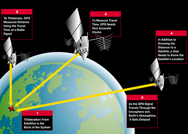
GPS satellites continuously transmit signals containing information about their position and extremely precise time.
A GPS receiver on Earth listens to signals from multiple satellites.
By comparing when those signals were transmitted with when they were received, the receiver can estimate its distance from each satellite.
With signals from enough satellites, the receiver can calculate its three-dimensional position.
This process is one of the greatest engineering achievements of the modern world.
And GPS is no longer used only for navigation.
It supports transportation, aviation, shipping, telecommunications, agriculture, emergency services, financial systems, logistics, smartphones, drones, robotics and many other technologies.
Understanding how GPS works therefore means understanding one of the most important technologies behind the modern digital economy.
What Does GPS Stand For?
GPS stands for:
Global Positioning System.
It is a satellite-based navigation system operated by the United States.
GPS is part of a larger category known as GNSS, or Global Navigation Satellite Systems.
Other major satellite navigation systems include:
- Galileo
- GLONASS
- BeiDou
GPS was originally developed for military applications, but it eventually became one of the most widely used technologies in civilian life.
Today, GPS receivers are found in smartphones, cars, watches, aircraft, ships, agricultural equipment, drones and industrial systems
How Many Satellites Does GPS Use?
A GPS receiver does not need to communicate with a single special satellite.
Instead, it listens to multiple satellites.
The GPS constellation is designed so that users around the world can normally see multiple satellites at any given time.
Having several satellites available is essential because one satellite cannot determine a receiver's complete location.
Multiple measurements are required.
What Is a GPS Satellite?
A GPS satellite is a spacecraft designed to transmit navigation signals toward Earth.
Each satellite contains extremely precise timing equipment.
The satellite knows:
- The current time
- Its orbital position
- Navigation information
- Signal information
It broadcasts this information continuously.
A receiver uses the incoming signals to calculate its position.
Why Are Clocks So Important to GPS?
Time is at the heart of GPS.
Radio signals travel at approximately the speed of light.
That means even a tiny timing error can translate into a significant positioning error.
For example, if a receiver incorrectly estimates when a signal was transmitted, it may calculate the wrong distance to the satellite.
Because GPS positioning depends on distances to multiple satellites, timing errors can affect the final location.
This is why GPS satellites carry extremely accurate clocks.
GPS Uses Atomic Clocks
GPS satellites use highly accurate atomic clock technology.
Atomic clocks provide the precise time reference required for satellite navigation.
The receiver does not necessarily need an atomic clock of its own.
Instead, it compares the timing information contained in satellite signals and solves for both:
- Position
- Receiver clock error
This is an important part of GPS mathematics.
How Does a GPS Satellite Know Where It Is?
GPS satellites travel in carefully controlled orbits.
Ground-based control systems continuously monitor the satellites.
They calculate orbital information and update navigation data.
The satellites then broadcast information that tells receivers where the satellites are expected to be at specific times.
The GPS receiver uses this information when calculating its own position.
The Basic GPS Process
The GPS positioning process can be simplified into several steps.
Step 1: Satellites Broadcast Signals
GPS satellites continuously transmit navigation signals.
Step 2: Your Receiver Detects the Signals
A phone, vehicle or GPS tracker receives signals from multiple satellites.
Step 3: The Receiver Measures Signal Timing
It determines how long each signal appears to have traveled.
Step 4: Distance Is Estimated
The receiver uses signal travel time and the speed of light to estimate distance.
Step 5: Multiple Distances Are Combined
The receiver calculates the location where those distance measurements intersect.
Step 6: Position Is Determined
The receiver produces latitude, longitude and altitude information.
This entire process can happen extremely quickly.
What Is Trilateration?
One of the most important terms in GPS technology is trilateration.
Many people mistakenly call GPS positioning "triangulation."
Technically, GPS primarily uses trilateration.
Triangulation is based on angles.
Trilateration is based on distances.
GPS determines distances between the receiver and satellites and uses those distances to calculate position.
How Trilateration Works
Imagine you know that you are exactly 100 kilometers away from a particular point.
Your possible locations form a circle around that point.
Now imagine another point that you are also 100 kilometers away from.
The two circles intersect at one or two possible locations.
Add a third measurement and the possible location becomes much more precise.
GPS applies this concept in three dimensions.
Instead of circles on a flat map, the measurements create spheres around satellites.
The receiver calculates where those spheres intersect.
Why Does GPS Usually Need Four Satellites?
Three satellites can provide information about three-dimensional position under simplified conditions.
But a real GPS receiver also needs to account for its own clock error.
The receiver's clock is not as precise as the atomic clocks on GPS satellites.
That introduces another unknown.
The receiver therefore typically uses at least four satellites to solve for:
- Latitude
- Longitude
- Altitude
- Receiver clock offset
This is one of the most important concepts in GPS positioning.
The Fourth Satellite Solves the Timing Problem
Imagine that a receiver uses three satellites.
It may have enough information to estimate its spatial position.
But if the receiver's clock is slightly wrong, every calculated distance can also be wrong.
The fourth satellite provides another equation.
The receiver can use the additional measurement to determine the clock error.
This allows the system to calculate an accurate position.
What Is a Pseudorange?
The distance calculated by a GPS receiver is commonly called a pseudorange.
The term "pseudo" is important because the measurement includes timing errors.
The receiver estimates how long the signal took to travel.
But the receiver's clock is not perfectly synchronized with the satellite clocks.
Therefore, the calculated distance is not initially a perfect geometric distance.
The receiver solves for the clock error as part of the positioning process.
GPS Signals Travel at the Speed of Light
GPS signals are radio waves.
Radio waves travel at approximately the speed of light.
This is why GPS requires extremely accurate timing.
If a signal travels for a certain amount of time, the receiver can estimate how far it traveled.
Even tiny timing errors matter because light travels an enormous distance in a very small amount of time.
Why GPS Can Be So Accurate
Under good conditions, modern GPS receivers can determine location with impressive accuracy.
The final accuracy depends on many factors, including:
- Satellite geometry
- Atmospheric conditions
- Receiver quality
- Signal reflections
- Obstructions
- Correction services
- Number of satellites
- Available frequencies
Consumer devices typically provide meter-level positioning under favorable conditions, while specialized systems can achieve far greater precision using advanced techniques.
What Is GPS Accuracy?
GPS accuracy describes how close the calculated location is to the receiver's actual position.
For example, if a device reports a location 3 meters away from the actual position, its error is approximately 3 meters.
Accuracy can change constantly.
A receiver may perform extremely well in an open field but poorly between tall buildings.
Why GPS Does Not Always Show the Exact Location
GPS is not perfect.
Several factors can reduce accuracy.
These include:
Buildings
Tall structures can block or reflect signals.
Trees
Dense vegetation can weaken signals.
Mountains
Terrain can obstruct satellite visibility.
Atmosphere
Signals can be delayed as they pass through Earth's atmosphere.
Multipath
Signals can bounce off buildings and other surfaces before reaching the receiver.
Satellite Geometry
The arrangement of visible satellites affects positioning quality.
What Is Multipath Error?
Multipath occurs when a GPS signal reaches the receiver through multiple paths.
For example, a signal may travel directly from a satellite to the receiver.
Another copy of the signal may bounce off a building first.
The receiver can receive both signals.
The additional reflected signal can create measurement errors.
This is one reason GPS accuracy can be worse in dense urban environments.
Why GPS Works Better in Open Areas
When you are in an open area, your receiver can usually see more satellites without obstruction.
This gives the receiver more measurements.
The signals are also less likely to be blocked or reflected by buildings.
That can improve positioning performance.
This is why GPS often works very well in open fields, highways and outdoor environments.
Why GPS Can Struggle Indoors
GPS satellites are far above Earth.
Their signals are relatively weak when they reach the ground.
Buildings can block those signals.
As a result, GPS may perform poorly inside:
- Houses
- Shopping centers
- Parking garages
- Underground areas
- Large office buildings
Modern smartphones therefore use other technologies to improve indoor positioning.
GPS Is Often Combined With Other Technologies
A smartphone's location system may use more than GPS.
It can potentially combine information from:
- GPS
- Other GNSS systems
- Wi-Fi
- Cellular networks
- Bluetooth
- Motion sensors
This creates a more complete location system.
What Is A-GPS?
A-GPS means Assisted GPS.
It uses network connectivity to help the device acquire satellite information faster.
Instead of starting completely from scratch, the device can receive assistance data through a cellular or internet connection.
This can reduce the time required to obtain an initial GPS position.
What Is GPS Tracking?
GPS tracking means using a GPS receiver to determine the location of an object or person and then transmitting that information to another system.
A GPS tracker may contain:
- GPS receiver
- Cellular modem
- Battery
- Processor
- Antenna
The GPS receiver determines location.
The cellular connection can send that location to a server.
A user can then view the position through an application or website.
GPS Tracking vs GPS Navigation
These terms are related but different.
GPS Navigation
Helps a user determine where they are and how to reach a destination.
GPS Tracking
Records or transmits the location of an object over time.
A vehicle fleet tracker is an example of GPS tracking.
A smartphone navigation app is an example of GPS navigation.
How Vehicle GPS Tracking Works
A typical vehicle tracker operates like this:
- GPS satellites transmit signals.
- The tracker receives those signals.
- The tracker calculates its position.
- A cellular modem sends the location to a server.
- The server stores the information.
- The user views the vehicle on a map.
This process can repeat every few seconds or minutes depending on the system.
GPS Tracking Requires More Than Satellites
The satellites only provide the positioning signals.
A tracking system also requires communication.
The GPS receiver knows where it is.
But if you want to view that location remotely, the tracker needs a way to send the information.
That is why many GPS trackers include cellular connectivity.
GPS and Smartphones
Modern smartphones contain sophisticated GNSS receivers.
They can often use multiple satellite systems.
Depending on the device, the receiver may use GPS together with other GNSS constellations.
This improves the number of available measurements and can improve positioning availability.
How Google Maps Gets Your Location
Navigation applications can use multiple sources of information.
Satellite positioning can provide global location.
Wi-Fi and cellular networks can help when satellite signals are weak.
The phone's motion sensors can also help estimate movement.
The application then combines the information.
This is why your location can sometimes remain reasonably accurate even when GPS reception is not ideal.
GPS and Cellular Positioning
Cellular networks can help estimate location based on nearby towers.
This is generally less precise than good GPS positioning, but it can be useful when satellite signals are weak or unavailable.
Modern smartphones can combine both methods.
GPS and Wi-Fi Positioning
Wi-Fi networks can also provide location clues.
If a device detects known Wi-Fi networks, its location system may be able to estimate where it is.
This can be especially useful indoors.
GPS and Wearable Devices
Smartwatches and fitness trackers increasingly include GPS or GNSS receivers.
They can track:
- Running routes
- Cycling routes
- Walking paths
- Speed
- Distance
- Outdoor activities
The device can record location data and later display it on a map.
GPS in Aviation
GPS is an important component of modern aviation navigation.
Aircraft can use satellite positioning to support navigation and other systems.
However, aviation does not simply assume that GPS will always be perfect.
Aircraft navigation involves multiple systems and procedures designed to maintain safety.
GPS in Maritime Navigation
Ships use satellite navigation for positioning and route planning.
GPS can help determine a vessel's:
- Position
- Speed
- Direction
- Route
It can also integrate with electronic navigation systems.
GPS in Agriculture
Precision agriculture is one of the most impressive applications of GPS.
Farm equipment can use satellite positioning to follow extremely precise paths.
This can help farmers:
- Reduce overlapping passes
- Improve field mapping
- Optimize planting
- Improve harvesting efficiency
- Manage agricultural equipment
Advanced systems can achieve very high precision when combined with correction technologies.
What Is RTK GPS?
RTK stands for Real-Time Kinematic.
It is a high-precision positioning technique.
RTK uses correction information from a reference station or network.
These corrections can dramatically improve positioning accuracy compared with ordinary standalone GPS.
RTK is widely used in applications where centimeter-level positioning can be valuable.
GPS in Construction
Construction companies use high-precision positioning for:
- Surveying
- Machine control
- Site mapping
- Excavation
- Road construction
- Building layout
Machines can use GNSS information to understand their position relative to a digital construction plan.
GPS in Drones
Drones can use GPS for:
- Position holding
- Navigation
- Return-to-home functions
- Route planning
- Mapping
- Surveying
Professional mapping drones can combine GPS with high-precision positioning technologies.
GPS and Autonomous Vehicles
Autonomous vehicles require accurate positioning.
But GPS alone is not sufficient.
A self-driving vehicle may combine:
- GNSS
- Cameras
- Radar
- LiDAR
- Inertial sensors
- Digital maps
The vehicle uses these systems together to understand its environment.
Why GPS Is Important for Robotics
Outdoor robots need to know where they are.
GPS can provide a global positioning reference.
Robots can then combine GPS with local sensors to navigate toward destinations.
This is becoming increasingly important as autonomous delivery robots and industrial machines become more common.
GPS and Internet of Things
The Internet of Things includes connected devices that collect and exchange information.
Location-aware IoT devices can include:
- Asset trackers
- Fleet trackers
- Agricultural sensors
- Shipping containers
- Wearable devices
- Industrial equipment
GPS can provide location information for these devices.
GPS and Emergency Response
Location technology can help emergency responders determine where assistance is needed.
GPS-enabled devices can provide location information to applications and emergency systems.
Navigation systems can then help responders find the fastest route.
Accurate positioning can become especially important during disasters and search-and-rescue operations.
What Happens if GPS Signals Are Lost?
Modern systems increasingly use backup navigation methods.
These can include:
- Inertial navigation
- Other GNSS systems
- Cellular positioning
- Wi-Fi positioning
- Digital maps
- Cameras
- Optical navigation
The exact combination depends on the application.
GPS Jamming and Spoofing
GPS signals can be disrupted.
Jamming
Interference prevents the receiver from using GPS signals properly.
Spoofing
False signals attempt to make the receiver calculate an incorrect position or time.
These are important navigation-security issues.
Modern systems increasingly use sensor fusion and anomaly detection to identify suspicious GPS information.
Why GPS Needs Security
GPS is now part of critical infrastructure.
It supports:
- Transportation
- Communications
- Agriculture
- Aviation
- Maritime operations
- Emergency services
- Military systems
Protecting navigation signals and developing backup technologies is therefore increasingly important.
The Future of GPS Is Not GPS Alone
The next generation of navigation will probably combine several technologies.
A future vehicle may use:
GPS + Galileo + inertial sensors + cameras + maps + AI.
A future drone may use:
GNSS + visual navigation + inertial measurement.
A future spacecraft may use:
Optical navigation + star tracking + autonomous software.
This multi-layer approach can improve reliability.
NASA Is Developing GPS-Independent Navigation
GPS is primarily designed for users around Earth.
Spacecraft traveling deeper into space cannot always rely on GPS.
NASA has therefore been testing autonomous navigation technologies.
In August 2026, NASA reported that its Starling mission had demonstrated GPS-independent navigation using optical observations of objects in space. The FALCON system helps spacecraft determine their position without depending entirely on GPS. (nasa.gov)
This is an important step toward future autonomous spacecraft navigation.
Lunar GPS Could Be the Next Step
NASA is also working on navigation infrastructure for lunar missions.
In 2026, NASA delivered its NavCube3-mini navigation payload for integration into Intuitive Machines' Altus-1 lunar relay satellite.
NASA says the lunar relay is intended to provide communications and navigation services for astronauts and rovers operating around future lunar activities. (nasa.gov)
This could eventually lead toward a GPS-like navigation ecosystem around the Moon.
GPS Technology Is Moving Beyond Earth
For decades, satellite navigation was primarily associated with Earth.
Now the underlying concepts are being adapted for:
- Lunar navigation
- Autonomous spacecraft
- Deep-space missions
- Satellite swarms
- Space robotics
The fundamental requirement remains the same:
A spacecraft needs to know where it is.
How GPS Could Evolve in the Future
Future navigation systems may become increasingly intelligent.
Instead of simply receiving satellite signals, a navigation system could continuously evaluate multiple sources.
It might ask:
- Which satellites are visible?
- Are the signals trustworthy?
- Do they agree with the vehicle's sensors?
- Does the calculated position match the map?
- Is there evidence of interference?
- Which navigation source has the highest confidence?
AI could help automate these decisions.
Why GPS Will Remain Important
Despite the development of alternative navigation technologies, GPS is unlikely to disappear.
It has a massive installed ecosystem.
Billions of devices are already designed to use it.
Its infrastructure has been developed over decades.
Its signals support global applications.
Instead of disappearing, GPS is likely to become one component of a broader positioning ecosystem.
GPS Modernization in the United States
The U.S. continues to modernize GPS through successive satellite generations.
The GPS III and GPS III Follow-On programs are part of this effort.
Space Systems Command describes GPS as a critical positioning, navigation and timing capability for global users and military operations. (ssc.spaceforce.mil)
The objective is to ensure that GPS remains capable as technology and user requirements change.
Why GPS Is One of the Most Important Technologies Ever Built
GPS changed the relationship between people and geography.
Before satellite navigation became widely available, determining an exact location often required maps, landmarks or specialized equipment.
Today, a small device in your pocket can calculate its location almost anywhere outdoors.
That capability has transformed:
- Travel
- Logistics
- Agriculture
- Transportation
- Science
- Emergency response
- Communication
- Business
GPS has effectively turned location into a digital data point.
The Hidden Technology Behind a Simple Blue Dot
The blue location dot on a smartphone map looks simple.
Behind it is an enormous technological ecosystem.
It involves:
Satellites
Atomic clocks
Orbital calculations
Radio signals
Ground control
Mathematics
Digital maps
Sensors
Software
Data networks
All of these components work together to create the location displayed on your screen.
Frequently Asked Questions
How does GPS know my location?
GPS satellites transmit signals containing precise timing and orbital information. Your receiver compares signals from multiple satellites and calculates its position based on the estimated distances to those satellites.
How many satellites are needed for GPS?
A receiver typically needs signals from at least four satellites for a full three-dimensional position while also solving for receiver clock error.
Does GPS use triangulation?
GPS primarily uses trilateration, which determines position using distances rather than angles.
Why does GPS need four satellites?
The fourth satellite allows the receiver to solve for its clock error in addition to its three-dimensional position.
Does GPS work without the internet?
Yes. A GPS receiver can calculate a position without an internet connection. However, internet or cellular connectivity can provide assistance data and other location information.
Does GPS work without mobile signal?
Yes, standalone GPS can work without cellular service as long as the receiver can obtain usable satellite signals.
Why is GPS inaccurate in cities?
Tall buildings can block satellite signals and cause reflections known as multipath. These effects can reduce positioning accuracy.
Can GPS work indoors?
GPS can work poorly indoors because satellite signals are weak and buildings can block them. Devices often use Wi-Fi, cellular positioning and other sensors to improve indoor location.
What is RTK GPS?
RTK, or Real-Time Kinematic positioning, is a high-precision technique that uses correction information to achieve significantly better positioning accuracy than standard standalone GPS.
What is GPS tracking?
GPS tracking uses a receiver to determine the location of an object and typically transmits that information to another system so the location can be monitored remotely.
Is GPS the same as GNSS?
No. GPS is one global navigation satellite system. GNSS is the broader term that includes GPS and other systems such as Galileo, GLONASS and BeiDou.
Can GPS be spoofed?
Yes. GPS spoofing involves transmitting false signals that can potentially cause a receiver to calculate an incorrect position or time.
Can GPS be jammed?
Yes. Interference can prevent a receiver from properly detecting or processing GPS signals.
Will GPS still be important in the future?
Yes. GPS is expected to remain a major positioning, navigation and timing technology while increasingly working alongside other GNSS systems, sensors and autonomous navigation technologies.
Conclusion
GPS may look simple when you use it on a smartphone, but the technology behind that small blue location dot is extraordinarily sophisticated.
Thousands of miles above Earth, GPS satellites continuously transmit precisely timed signals.
Ground systems monitor satellite orbits.
Receivers measure signal timing.
Mathematical algorithms calculate distances.
Multiple satellite measurements are combined through trilateration.
The receiver then produces the latitude, longitude and altitude that applications use for navigation and tracking.
The remarkable part is that all of this can happen in seconds using hardware small enough to fit inside a smartphone.
But GPS is also evolving.
Modern navigation systems are increasingly combining GPS with other GNSS constellations, inertial sensors, cameras, digital maps and AI.
The reason is simple: future technology cannot afford to depend on one source of positioning information.
Autonomous vehicles, drones, robots and spacecraft will need increasingly reliable navigation.
NASA is already exploring GPS-independent navigation for spacecraft, while lunar relay and navigation technologies could eventually extend similar concepts beyond Earth. (nasa.gov)
At the same time, the United States continues to modernize its GPS infrastructure through programs such as GPS III and GPS IIIF.
This means the future of GPS is not simply about getting a more accurate location on a phone.
It is about creating a global—and eventually interplanetary—navigation infrastructure that machines, vehicles, spacecraft and humans can depend on.
From a smartphone in your hand to a rover exploring the Moon, the fundamental question remains the same:
Where am I?
GPS was created to answer that question.
The next generation of navigation technology will make that answer faster, smarter, more reliable and increasingly independent of any single system.
That is why GPS remains one of the most important technologies shaping the future of transportation, communication, automation and space exploration.











No responses yet